Introduction
Davis Hydro, LLC intends to apply to the FERC for a license to retrofit the Rock Creek dam, and use the dam base instream release water for a small hydropower project with no changes in flows. This document is being circulated to all concerned stakeholders in this area, specifically to form a basis of consultation with the State and Federal agencies for their concerns. This filing describes the Rock Creek Retrofit Power Project (the Project), addresses environmental concerns, and invites comment and criticism of the plan.
Background of Davis Hydro, LLC
Davis Hydro, LLC (Davis Hydro) is organized to develop small hydro, and to perform related fisheries research. In cooperation with others we are operating the Sandy Hollow site in New York state, and are active at sites in California and Vermont. The engineering ideas and environmental concerns in this consultation package have been discussed informally with several agencies and interested parties over the past three years, but formal submittal has been delayed due adverse developments in the green power market. Currently, favorable contracts are becoming possible, and Davis Hydro hopes to develop this site in a manner most compatible with everyone’s environmental goals.
Relations with PG&E
Because the Project is located on, in, and immediately next to a Pacific Gas and Electric Co. (PG&E) owned dam, their cooperation was sought and has been generously provided. During the past three years we have met with administrative, management, and engineering staff from PG&E - primarily in 2001. PG&E staff have summarized their concerns and procedures both informally and in letters. Their concerns include:
- their responsibilities under their new FERC License to maintain environmental quality, specifically in-stream fish flow at all times;
- liability issues;
- non-interference with dam operations;
- dam integrity, and eventual equipment removal;
- ability to transmit the power out of the valley as there is another small hydropower site on the same 12 kV line.
Within the bounds of these and other engineering concerns, PG & E has given positive indications on the potential feasibility of this Project. They have provided guidelines on expected compensation for the site’s usufruct, requested a drawing account for expenses, and continuing to provide cooperation whenever asked. Specific significant communication is noted in the Bibliography, and copies of letters are available on request.
Rock Creek Retrofit Power Project: Background
The Rock Creek Diversion Dam on the North Fork of the Feather River has recently obtained a new License from FERC to divert most of the water out of the river to the Rock Creek Power House. Under the terms of this license the dam owner, PG&E, is required to release water according to the Rock Creek – Cresta Settlement Agreement (the Settlement) dated December 2000. That agreement addressed a full range of concerns of interveners, agencies, and PG&E. By far, the main issue was fish habitat, primarily the direct and indirect effects of flow volumes, flow timing, temperature, and sediment transport on fish. For related documents see Bibliography and Chronological File provided in Attachment I. On October 24th 2001 FERC issued a New License (the License) that is based solidly on the Agreement.
Detailed Maps:
The following external references are made concerning existing structures: FERC Project 1962 Exhibits F & G for the Rock Creek Diversion Dam (Bibliography). The relevant drawings are FERC Exhibit G Drawings No. 1962-1001, 1002, 1003 and Exhibit F FERC drawing 1007. Attachment I to this consultation package contains three drawings showing improvements: Plan, Elevation, and Site Plan the latter showing access, control house, and transmission interconnection[1].
Environmental Resources
For all Environmental Resource impacts, reference is made to the FERC License, the Settlement, and supporting documents outlined in the Bibliography. The following sections address a subset of these resources relevant to this project. The other issues for species are addressed in the License and Settlement, and this project will reference those documents. This application is not ignoring any of the issues addressed in the Settlement, but for many issues, this small project fits clearly within the bounds of the findings of the very recent Agreement and Project 1962 License. All issues will be addressed in this Project license application. Unless directed otherwise by an agency review through this consultation Process, reference is, and will be made to the Settlement and License[2] on all issues not discussed below.
Cultural Resources
Historical and Archaeological
 The Feather River Area in
the Plumas National Forest has been used by humans for at least 8,000
years. It was the homeland of the
Mountain and Konkow and Maidu Indian tribes.
The Washo and Paiute tribes also lived along the river’s eastern
boundaries.
The Feather River Area in
the Plumas National Forest has been used by humans for at least 8,000
years. It was the homeland of the
Mountain and Konkow and Maidu Indian tribes.
The Washo and Paiute tribes also lived along the river’s eastern
boundaries.
The ruggedness of the area discouraged exploration until the Gold
Rush. Spanish exploration in the early
1800’s was limited to the Sacramento Valley.
The Hudson Bay Fur Company, however, had entered the Plumas Region by
the early 1830’s. Gold miners spread
into the area by 1850. Although Indians
had known about the Sierra’s 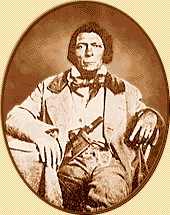 lowest pass for centuries,
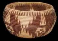
James Beckwourth, (shown at right) an African American, did not formally “discover”
it until 1851. Immigrants and miners
soon began moving through the pass and into the area. Gold claims around the Project site, camps, and towns such as
Pulga and Belden, sprang up along the valley as miners searched for that elusive
metal. The towns and remains of several
placer mining claims are in the area of this Project, and the remains[3]
of mills and works can be seen from the Project.
lowest pass for centuries,
James Beckwourth, (shown at right) an African American, did not formally “discover”
it until 1851. Immigrants and miners
soon began moving through the pass and into the area. Gold claims around the Project site, camps, and towns such as
Pulga and Belden, sprang up along the valley as miners searched for that elusive
metal. The towns and remains of several
placer mining claims are in the area of this Project, and the remains[3]
of mills and works can be seen from the Project.
While mining brought people into the area, other primary production industries allowed them to remain. As the gold fields began to play out, timber and agriculture became the mainstay of the economy. President Theodore Roosevelt established the Plumas National Forest in March 1905. Its boundaries roughly encompass areas surrounding the branches of the Feather River[4].
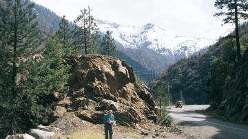
The immediate area of the Project is a beautiful narrow gorge on the North Fork of the Feather River. The project area has been heavily modified, first by gold miners[5], later by railroad and highway engineers, and finally by the crews who built the dam and its adjacent construction yards. The dam and immediate storage areas are built on an area cleared to bedrock. The project area contains the dam next to the modern (1949) alignment of State Highway 70, and a small work area between the road and the dam. All project works including transmission will take place in these areas. There is no possibility of affecting pre-industrial remains in the area affected by this project. No cultural resource impact of any kind is expected.
Natural Resources
 Scenic Beauty and
Aesthetics
Scenic Beauty and
Aesthetics
Feather River National Scenic Byway is a 130-mile route featuring incomparable engineering integrated with natural beauty and diversity in terrain, landscape, wildlife habitat, and human usefulness[6]. Designated for hydropower and engineering in the area as well as for its natural beauty, it is an awesome juxtaposition of 20th century train and hydropower engineering, and incomparable scenery.
 Any season provides unique views of the
contrast between man’s small steel and concrete structures and magnificent
mountains. Trains rattle up the valley
constantly, filling the huge space with rumblings echoing off the canyon
walls. In the spring there are nearly
100 waterfalls, brilliant wildflowers, and brightly colored boats of daring
kayakers riding the whitewater. In the
summer, the sun sparkles off the river as swimmers, fishing enthusiasts, and
gold miners enjoy the cool water. The
beautiful fall colors along the steep mountain slopes make autumn spectacular. In the winter, the river rushes and the
snow-capped mountains contrast sharply with the granite and slate at river
level, while man extracts tremendous amounts of hydroelectric power by moving
most of the river from reservoir to powerhouses through long tunnels invisible
within the granite Mountains lining the valley[7].
Any season provides unique views of the
contrast between man’s small steel and concrete structures and magnificent
mountains. Trains rattle up the valley
constantly, filling the huge space with rumblings echoing off the canyon
walls. In the spring there are nearly
100 waterfalls, brilliant wildflowers, and brightly colored boats of daring
kayakers riding the whitewater. In the
summer, the sun sparkles off the river as swimmers, fishing enthusiasts, and
gold miners enjoy the cool water. The
beautiful fall colors along the steep mountain slopes make autumn spectacular. In the winter, the river rushes and the
snow-capped mountains contrast sharply with the granite and slate at river
level, while man extracts tremendous amounts of hydroelectric power by moving
most of the river from reservoir to powerhouses through long tunnels invisible
within the granite Mountains lining the valley[7].
Visually, this Project would have a 12’x16’ square masonry switch house and pad mounted transformer in the area next to the dam. The penstocks and turbines would be visible on the downstream dam face. The trash rack would be less obvious, and out of sight for most observers.
Animal Resources
The Project is on a dam face in the narrows of a very steep gorge. While there are extensive natural resources in the surrounding Plumas National Forest[8], natural resources in this part of the industrial site are limited to waterborne species. Extensive management plans and studies are underway for many species, from invertebrates to eagles, incorporated in the Project 1962 License. None of these would in any way be influenced by this project except possibly fish. Therefore the fish, fish habitat, fish disease, flow control for fish, water temperature and quality, are the focus of most of the key documents in the Project License, and will be discussed here.
Fish Habitat
The baseline work on fish in this area is contained in the ROCK CREEK-CRESTA Project (FERC 1962) Fisheries Management Study, North Fork Feather River, California July 1, 1988 (Management Study). This study was prepared by the California Department of Fish and Game and the Pacific Gas and Electric Company. Additional survey work focusing on game fish habitat was done by Enplan, who more recently sampled the species in the Rock Creek Reservoir[9]. Enplan specifically addresses the reasons, other than diseases, for the near lack of trout in this area. This survey focused on the number of fish in the reservoirs above Rock Creek and Cresta Dams and discusses the causes for finding so few game fish.
In the immediate Rock Creek Reservoir, according to the Enplan survey, the predominant species were hardhead, with only 3 trout caught using electro fishing and gill netting. The main non-disease problem in this area, identified by Enplan and others, is that the habitat of the River has little gravel and few riffle areas needed by trout. The Management Study found that trout are found primarily in the tributary streams, where they spawn and live. The main stem has few trout within the Rock Creek and Cresta reaches due to the lack of suitable gravels. The reach is dominated by scoured large boulders and reservoirs, with very few riffle areas or low velocity areas with shelter from predators. The CDFG surveyed the reaches and reported in 1988 that only 0.1 % of the area has suitable spawning areas (Enplan). The spawning area problem, coupled with disease in the area, severely limits fish in the main stem of the River and specifically in the reservoirs above, and the reach below, the Rock Creek Dam. These factors have been addressed in the past by intermittently restocking the populations in this area with disease resistant fish. Juveniles are common in the tributaries but are not found in the main stem. Currently, there are extensive studies of fish and fish habitat going on as part of the Agreement under Condition 7.
Specific to our project, the area in front of the trash rack is between 30 and 50 feet deep and the trash rack is on an exposed, barren, vertical face of the dam. This stem/reservoir area is singularly devoid of habitat, shelter, and feeding opportunities that might attract adult or juvenile fish.
Disease
Informal preliminary meetings with the US Fish and Wildlife Service, the US Forest Service, and California Fish and Game, suggest that the key issues for fisheries resources and in particular for trout at the site for the Project outlined in this consultation are flow and disease[10]. They reported prevalence of the disease Ceratomyxa shasta[11], which primarily impacts the fish in the main stem of the river. Wood in 1979 showed that C. shasta is often found in reservoir environments typical of this river section. The causes and lifecycle of this disease are unclear, however, high water temperature is a contributing factor to its prevalence. The main stem area has significant temperature problems that are being addressed in the Agreement, and over which this Project has no influence. The fish pass downstream from this reach to the Oroville Dam. They have been been identified as a source of the disease in the Oroville Salmon Hatchery below this dam (Keffe). Because restocking, resistant species, habitat improvements, and disease controls may change this premise, the existing and proposed methods of dam passage are now discussed.
Spillway Mortality
 Spillway mortality and morbidity are caused directly
by physical damage due to spillways, and indirectly from the dissolved gas that
is created when a spillway discharge overly mixes air into a stilling
basin. Physical spillway mortality is
documented by Larinier as varying widely, from 0-4% at Bonneville to a reported
high of 37 % at the Lower Elwha dam.
Spillway mortality and morbidity are caused directly
by physical damage due to spillways, and indirectly from the dissolved gas that
is created when a spillway discharge overly mixes air into a stilling
basin. Physical spillway mortality is
documented by Larinier as varying widely, from 0-4% at Bonneville to a reported
high of 37 % at the Lower Elwha dam.
Indirectly, spillways, and especially jets into basins[12] increase dissolved gas supersaturation (DGS) that causes morbidity and mortality in fish[13]. Super-saturated levels of dissolved gas can be produced at spillways due to the driving of bubbles deep into the stilling basins downstream. The resulting high levels of dissolved oxygen and nitrogen can cause serious injury or death to fish exposed to this condition (Larinier, Fidler. et al., Scholz).
An environmental benefit of this project will be the reduced levels of spillway mortality and total dissolved gas pressure (TGP) downstream of the project by reducing the flow from the jet into the stilling basin and flow down the spillway.
Turbine Mortality
Healthy adult trout will, uncommonly, pass through a small hydro facility, as is evidenced by the prevalence of excellent trout streams with resident brown and rainbow trout in numerous small hydro dams in the eastern United States. The stream areas near these hydro facilities have the best trout fishing in the area, with many small hydropower rivers supporting native populations of trout including rainbow[14].
A percentage of fish, of any size, that pass through the reaction turbines will suffer varying amounts of mortality. There will be small fish passing downstream as juveniles. It is expected that they will suffer approximately a 3-12% mortality depending on their size, and no feasible sized trash rack spacing will stop them because many will pass through a very narrow slit. If the downward migration of these small fish were stopped with a very fine trash rack, the areas below the dam would suffer declining restocking opportunities[15]. The Enplan survey, done by electrofishing and gillnetting, was unable to find any small trout in the Rock Creek Reservoir, and only found three large ones[16]. The earlier Fisheries Management Study of June 1982 trapped and caught three trout. During a later study conducted in the first half of 1984, two trout were caught during 53 trap days[17].
During informal Stage 0 consultation with agencies, trash racks and turbine mortality was of considerable interest. To address that interest, Attachment IV is included as a review of turbine and trash rack mortality studies.
Fish Populations: Summary
Dams change the sediment transport, and therefore the habitat along the rivers. The removal of gravel from the river beds dramatically changes the habitat and reproductive carrying capacity of the streams. Eastern micro-hydro sites typically have small dams (from the textile/wood/paper mill days) with no bypass diversion reach. These dams typically “silt up” quickly, and pass all new sediment down stream. While this sediment is a problem in the turbine works, it solves the habitat problem assuring a ready supply of gravel in many micro-hydro installations. This contrasts with the North Fork of the Feather River.
At Rock Creek, the game fish population in the upstream and downstream reaches is limited by habitat (Enplan), disease, and the related issue of temperature[18], which dictate the carrying capacity of a region. These factors are unlikely to be influenced by small changes in the passage survival of juvenile fish. These factors effectively limit population in these reaches of the river. Currently, juvenile fish pass downstream in several ways:
· in floods that overtop the spillways,
· through the existing trash rack,
· through the outlet jet, and through the sluiceway gate.
For most of the release volume, our Project will substitute the turbines for most of the current release using these methods.
Davis Hydro recognizes as a goal the enhancement of the environment and especially fisheries in this area. We recommend that we work with PG&E to effect any improvements to the habitat that are possible. We recognize that the turbine passages will cause more mortality than spillway passage, but this is unlikely to be observed given the very small populations present.
Recreation
Recreation at this site is dictated by the operation of FERC project 1962. This project in isolation has no direct or indirect recreational opportunities, as the public is ill advised to pass in the area just above or below the dam. Above the dam the public is dissuaded from approaching the water diversion inlets and spillway gates because they open without warning. Below the dam, the public is advised to avoid the gorge area due to the potential for rapid increases in flow releases.
In balancing, recreation and hydropower, Davis Hydro recognizes its obligation to promote recreation in the area. Therefore, it is suggested that Davis hydro work with PG&E to support PG&E’s efforts in this area, in a mutually agreeable manner.
Existing Physical Structure
 The project is located at, in, and on, the
Rock Creek Diversion Dam[19],
located in Plumas County at approximately milepost P-12.3 of California Route
70. The dam‘s physical composition was
described originally in PG&E drawings 402281 and 402282, with updated elevations
and corrections in PG&E drawing 451770[20].
The project is located at, in, and on, the
Rock Creek Diversion Dam[19],
located in Plumas County at approximately milepost P-12.3 of California Route
70. The dam‘s physical composition was
described originally in PG&E drawings 402281 and 402282, with updated elevations
and corrections in PG&E drawing 451770[20].
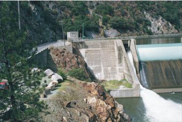
The dam is constructed of concrete, with steel spillway gates. It is 126 feet high (stream bed centerline to top of cement), and has a 550 foot crest length.
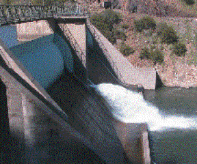
It is a concrete gravity dam built in approximately 1949 and is in excellent condition. It has two major 124’ spillways. Each spillway has 28’ drum gates, maintained at a raised elevation of 2,216 feet. There is also a smaller 22.5 feet wide fixed spillway at fixed elevation 2201.2 (all above MSL USGS datum NAD-29). The picture to the left shows the fish instream release on the right. The western drum gate is in the center and the operating sluiceway and the area for the turbines are on the left, and shaded.
There is about 14 feet of freeboard from the main spillway gates when they are up, and 42 feet when down. There are three unused low-level gated outlets of 7’8” inside diameter. There is one recently installed 30” high level outlet, with a trash rack with 2 5/8ths inch spacing, exiting near the center of the spillway face. Finally, there is a 22.6’ wide sluiceway used in combination with the 30” discharge for fish and recreation instream releases.
There is one other detached structure – an inlet structure to the rock creek diversion tunnel. This diversion operation is critical to the operation of the Rock Creek section FERC Project 1962.
Proposed General Engineering Design
Starting upstream, Davis Hydro would likeproposes to install the following equipment.
Trash Booms
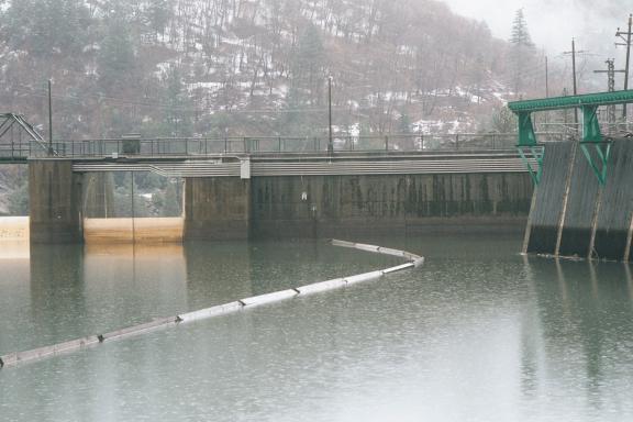
PG&E’s trash boom (see next picture below) would be moved slightly to the left to allow placement of the new trash racks. A new trash curtain would be run from the diversion structure from the same point near the sluiceway. A second new small trash boom will extend from the shore to the upstream end of the existing Project 1962 diversion inlet, parallel to its face.
Trashrack and Inlet
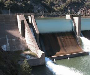
A new trash rack will be installed on a recessed wall of the dam (at the white spot on the wall) to the North of the sluiceway. This area is quiet and out of all flows. The picture shows the existing log boom on the right the 22 foot sluiceway. This log boom will be moved slightly toward the sluiceway shown on the left.
This picture looks downstream on the north or road side of the dam. The large structure on the right of this picture is the existing trash rack covering the diversion down to the Rock Creek Power House. The proposed trash rack will be placed exactly at the center of the picture at the end of the existing log boom. It will have a bar spacing as approved by FERC. Trash rack spacing is proposed at a maximum of 1.75 inches between bars, with a maximum face approach velocity of .65 feet per second or less.
There will be new inlets through the wall of the dam, near the road behind the new trash rack. These will have a diameter of just over 4’ on the downstream end and ellipse-shaped holes on the upstream end to clear the inside of 5 foot by 7’ slide gates. There will be a trash rack cleaner on the top of the dam next to the trash rack, smaller, but somewhat similar to the one shown on the existing diversion.
Fish Diversion
Compared with the minute technology of upstream fish
passage, downstream passage technology remains experimental. Except for spill, the variety of the
physical and behavior approaches to downstream passage has met with about {3 to
87%} success. Levels of effectiveness exceeding 50% passage are difficult to
achieve, or if achieved, are difficult to sustain.[21] The technology for downstream passage of
anadromous fishes is not mature, and additional research is needed to identify
suitable alternatives that have applicability across sites. Also needed are suitable measures to divert
and bypass resident species away from turbine intakes.
FERC, 2003
Diversion Penstocks:
 There will be three new 200’ steel penstocks
with a 42” diameter from the new trash rack on the west (highway) side of the
dam down to a turbine area on a curtain wall of the dam.
There will be three new 200’ steel penstocks
with a 42” diameter from the new trash rack on the west (highway) side of the
dam down to a turbine area on a curtain wall of the dam.
The penstocks will have air vents to act as vacuum breakers rising above the dam top, and will have a secure walkway down the downstream face of the dam to the turbine area. The three turbines would be mounted on the downstream wall to the left in this picture of the operating sluiceway. The work area is on this curtain wall and the adjacent flat area (shown with green grass cover). The top of the curtain wall is about 17’ feet above the stilling pond. The proposed total maximum discharge will be 280 cfs with a working net head of about 88 feet. The switch house would be behind the distribution pole in the top left of this picture.
Please note that this project area is completely isolated from PG&E’s operations.
Turbines
Three Francis or mixed flow turbines will have a capacity of 150 cfs, 80 cfs, and 50 cfs, respectively Each of these would be independent and have a single transformer and connection to the existing 12 kV transmission at the dam in common.
Generators and Interconnection
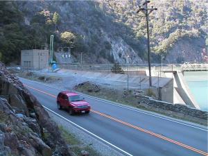 The new proposed transmission line would be
about 30 feet up to a distribution line on-site. It would connect the switch and control house near the road to
the transformer up to the existing distribution line directly overhead. The transmission interconnection point is
on-site[22]. The new proposed generation at the site
would be at 2,400 volts and would be transformed to primary voltage in a
pad-mounted vault located at the base of the pole[23]. Shown in the picture is the site of the
control/switch house, directly to the left of the existing distribution
pole. The proposed turbines are to the
right and down, out of sight from this view.
The new proposed transmission line would be
about 30 feet up to a distribution line on-site. It would connect the switch and control house near the road to
the transformer up to the existing distribution line directly overhead. The transmission interconnection point is
on-site[22]. The new proposed generation at the site
would be at 2,400 volts and would be transformed to primary voltage in a
pad-mounted vault located at the base of the pole[23]. Shown in the picture is the site of the
control/switch house, directly to the left of the existing distribution
pole. The proposed turbines are to the
right and down, out of sight from this view.
Operation
There is one impoundment related to this application, the Rock Creek Reservoir. It is an 80 acre reservoir at 2216 feet elevation. The storage capacity is 4,669 acre-feet at normal maximum surface elevation of 2216.2 feet. No changes of any kind are proposed to this reservoir. The site will be operated Run-of-River by PG&E, or under their direction, as is convenient to them. All organic “woody” would be returned to the river, as its decomposition contributes to habitat maintenance.
Stream Flow and Water Regime
Since this is a run-of-river project, flow through this area is controlled by PG&E who releases water under the Settlement Agreement flows, as codified into their new License. Since our diversion is from the PG&E releases, the appropriate reference document is the FERC license 1962 flow requirements. Since under the Agreement these flows are subject to changes depending on water availability and environmental conditions, the appropriate method to generate the stream flow data used in the engineering is to refer to the settlement conditions imposed in the Project 1962 license.
The total estimated average annual energy production and installed capacity is:
- 88 feet of net head – subject to PG&E’s operations
- 280 cfs max flow – subject to PG&E’s releases
· Three initial hydro generators would be used with a total nameplate capacity of 1.75 kW at 88’ feet of head. Expected average annual production would be 10.6 GWH. All turbines and generators are proposed as new. None exist.
Table 1. Proposed Turbines and Generators:
|
Generator |
CFS @ |
Design Head (feet) |
KW(design net) |
KW Capacity |
|
#1 |
50 cfs |
89’ |
297 |
300 |
|
#2 |
90 cfs |
88’ |
535 |
600 |
|
#3 |
150 cfs |
87’ |
892 |
900 |
|
Total |
290 cfs |
88’ median head |
1,724 |
1.8 MW |
The capacity of the site is limited by head and flow determined entirely by PG&E operation under their FERC License. This will be a run-of-river operation on whatever flow PG&E or a future licensee is required to release.
(5) Lands of the United States are enclosed within the proposed project boundary and include parts of Plumas Forest. The entire project is surrounded by the Plumas National Forest. To the south of the project is the Bucks Lake Wilderness.
(6) The proposed project would develop, conserve, and utilize,
in the public interest, the water resources of the region. This is a simple dam based release power
recovery project. It would use the
required run-of-river dam based release for power production under the Project
1962 License. This generation will
reduce the need for fossil fuel power generation in the West, and will slightly
lessen the burden of the bypass flow.
The project will provide PG&E with another set of tools to
accurately maintain the bypass flow below the Rock Creek Dam.
(4) The North Fork of the Feather River is not included in the National Wild and Scenic Rivers System. It is not wild, but controlled both for beauty, safety, and utility by PG&E.
Mitigation:
Having obtained an estimate of passage effectiveness,
it is important to be able to compare it with some criterion of acceptability.
What does a passage efficiency of 50% for an anadromous species mean to the
restoration of the stock in that river basin?
FERC 2003
The project has environmental benefits and costs. This project is designed to piggyback onto
Project 1962, and as such, will not
interfere in any manner with its operation.
The Rock Creek Retrofit Project will pass fish, and notably young
trout. When healthy trout repopulate
the Rock Creek Reservoir our turbines may have a more negative impact on these
fish than current dam passage procedures.
The decrease in potential Gas Bubble Disease from dissolved gas supersaturation
(DGS) from the current release mechanism will partially offset detrimental
effects of the turbines. Currently,
there are very few fish in the Rock Creek Reservoir due to its poor shoal
gravel conditions, high presence of C. shasta in these reservoirs, and
poor habitat. Nevertheless, with
Settlement related improvements in the eco-system, healthy fish may
return,
and this DGS mitigation may be useful.
To mitigate any potential impacts this new release mechanism may have, Davis Hydro would be pleased to discuss the following additional mitigation measures to effect fish enhancement in the Northern California Area:
· Continue to work with UC Davis on fish passage research for low head hydro. Currently innovative design efforts are focusing on open channel micro hydro installations primarily applicable in open rivers.
· Work with the Bureau of Reclamation to design and building a nature-like fish bypass for Red Bluff Dam. Davis Hydro believes that a nature-like bypass is both economical and practical at this site, and will work with interested parties to have it seriously considered.
· Continue research on fish guidance to bypass facilities, and attraction methods to improve fish passage at all dams. (See CEC project description on DavisHydro.com).
· Plant low bushes along both sides of the Rock Creek Reservoir to improve the near-shore habitat. This would be done under the advice and direction of CFG.
· Work under the direction of PG&E to assist with any environmental measures related to this project.
· Provide, if requested by PG&E, the accurate real time data on minute by minute releases to PG&E operators. This will allow them much finer control of discharges at all times.
While most of these measures are not directly related to this project, there is only a limited set of opportunities within this project itself. Davis Hydro is committed to enhancing the environment through responsible micro hydro.
Recommended Studies
No fish passage mitigation should be implemented
without extensive consideration of the need for studies to assess the
effectiveness of that mitigation.
FERC 2003
Currently completed is a 20 year sequence of studies, that culminated in the License. Since the issuance of the License, and underway currently, is a continuing series of studies on fish and fish population, catch, habitat, invertebrates, flow, recreation, temperature etc., that are monitoring every aspect of this site. These studies will be conducted every year for 15 years. PG&E, has filed on July 30th of last year the Fishery monitoring plan which is extensive[24].
The only feature unique to this piggyback retrofit project is the turbines and their associated mortality. Since this cannot be studied until after operation begins, this must be studied in advance in the literature. A literature review is presented in Attachment IV[25]. There is nothing that this applicant can add to that literature. In summary, Davis Hydro suggests that no separate further studies are warranted for this retrofit project, beyond those currently underway.
Monitoring:
.
All license articles requiring upstream or downstream
fish passage {should} also include an effectiveness monitoring plan as part of
that requirement.
FERC 2003
Because there are only a small number of game fish currently active in the Rock Creek Reservoir[26], and because the factors that control their viability: habitat, disease, and put and take operations overwhelm any impact of the differential mortality of spillway/jet vs. turbine mortality. Meaningful studies of the effects of fish passage of resident or quasi-resident species would be difficult at this time. Currently, under the License Monitoring Program in Appendix B section 5 of the Settlement Agreement there is extensive stem and Creek fish monitoring for 15 years. Davis Hydro will participate with PG&E in Condition No. 7 (Fishery Monitoring Plan) of their License if requested.
Other Concerns:
Other Hydropower Alternatives:
Consideration has been given to several other configurations:
1. Excavating the low level outlets and using them for hydropower: This alternative has the problem that the outlets are buried under many feet of gravel. Evaluating the environmental impacts of moving that gravel are beyond this Project’s potential.
2.
Digging a narrow channel around the dam and putting a
covered headrace under the road to a new powerhouse. This alternative is unrealistic in that the
road is on bedrock in this area, and a headrace would have to go over the top
of the current diversion tunnel.. Further, because it would mean
blasting and digging through many of feet of rock that forms the support for
the dam and road, major dam safety and cost questions would be raised.
3. Siphoning over the top of the dam after building it up slightly. This alternative is still possible with a cost not obviously different from the proposed design. Raising the dam on this side by 3”, with wide oval shaped siphons over it, is physically possible, but the whole area would have to be raised so as not to impede access to the dam from the wall. This will be discussed with PG&E when the engineering consultation is undertaken.
4. Two Penstocks and turbines instead of three. This alternative is under serious consideration. All other factors would be the same, except that there would be two larger turbines and generators instead of the proposed three. The down side is that this area is hard to reach with cranes, and larger equipment would be more unwieldy to install and repair. Also the transmission in this area might be a limiting factor, and smaller generators cause smaller transients on the line than larger ones. This will have to be resolved during PG&E’s engineering review.
5. Gravel Passing Turbine: This alternative involves installing a tougher turbine type that can accept some gravel and use this to pass gravel downstream. This alternative is under consideration to help PG&E meet Condition No. 14. It suffers in that the cost of the trash rack, intake, and turbine have to be tougher to withstand the continuous stream of gravel through the system. Further, since gravel of only an intermediate small size will pass for a given wear rate on the turbine runners, larger cobbles will have to be passed over the dam another way – over the dam with a larger trash rack, or down the present diversion. This is not difficult, be will require a more expensive trash rack assembly and a wider spaced trash rack than suggested for just the fish. There are also operating and maintenance issues.
PURPA Benefits
The applicant will not seek benefits under section 210 of PURPA.